Fire Tower Site Analysis For Northern New Jersey

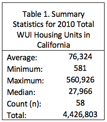
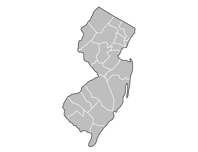
For my Advanced Geographic Information Systems (GIS) course, we were tasked with completing a GIS project for a community partner. I worked with the New Jersey Forest Fire Service to determine whether the state’s current fire towers in the Northern region should remain in place or be moved and also find the best locations for new fire towers. I determined that the current fire towers should remain in place and I also proposed two new locations that would fill in coverage gaps, thereby increasing visibility by 15%. Materials from this project, including my report and presentation, can be found below.

Note: the formatting of the written report looks best when downloaded and opened directly in Microsoft Word

Powered By EmbedPress

Powered By EmbedPress

Wildland-Urban Interface Changes in Madison, NJ from 1990 to 2010

In my Advanced GIS course, the project that I completed during the first half of the semester involved mapping the WUI by census block in Madison, New Jersey and visualizing the changes in population density and vegetation density between 1990, 2000, and 2010. The two main conclusions of this research were that 1) the majority of Madison is classified as WUI and 2) interface, which is where housing and vegetation meet, is the most common WUI class in this area. More details on this project can be found in the poster I made below.

Powered By EmbedPress

Analyzing the Wildland-Urban Interface Using Spatial Statistics

[Assignment 18] Figure 1 below shows total housing units in the WUI by county in the state of California using data obtained from the University of Wisconsin-Madison SILVIS LAB.

Figure 1. Total WUI Housing Units By County in California, 2010

As shown in Table 1 below, the average number of housing units in the WUI in 2010 for the state of California was 76,324 housing units. Los Angeles County has the most housing units in the WUI (560,926 housing units). Figure 1 above confirms this since this county has the darkest shade of blue, indicating a very high value. The total number of housing units in California in 2010 was more than 4.4 million.

I also wanted to see what kind of relationship exists between WUI housing units and median income. Figure 2 below depicts this relationship by plotting total WUI housing units in 2010 against median household income as defined by HUD. There is a moderate, positive correlation (r=0.37) between these two variables. The number of WUI housing units predicts only 13.7% of the variation in median household income.

Figure 2. Correlation Between WUI Housing Units and Median Income

Using Open Source Software to Make GIS Maps

[Assignment 17 part 1] Below is a set of maps I made using GeoDa, which is an open source software, to analyze relationships between households receiving public assistance and average household size in the sub-boroughs of NYC in 2000.

Powered By EmbedPress

[Assignment 17 part 2] Below are two maps I made using R Studio, which is another open source software. The first map is of New Jersey and the second map is of the United States and maps total WUI housing units in 2010 by state. Refer to my story map (assignment 12) or my midterm project for more details on what the wildland-urban interface (WUI) is. From the second map, it is evident that California has the most housing units in the county. Here is my code:

Schools Near Parks in Morris County, New Jersey

[Assignment 13] The map below depicts schools in Morris County, NJ (including public, private, and charter schools) and parks in Morris County, NJ with the goal of using buffer analysis to determine how many schools are located within 1 mile of parks. In Morris County, there are a total of 224 schools and 27 parks. Additionally, 49 of these schools, or approximately 22%, are located within 1 mile of a park. An important side note regarding the NJ parks data used in this map is that I believe this data does not actually contain all parks in New Jersey because there are parks in Morris County that I know of (such as Hedden Park and Brundage Park) which are not displayed in this map. Therefore, there are probably a lot more than 27 parks in Morris County and the percentage of schools within 1 mile of a park is likely much larger than the results of this map reveal.

css.php